This article is a stub. You can help the IndieWeb wiki by expanding it.
location is a key aspect of checkin & eventposts, and also sometimes an aspect of posts in general, like where a note or photo/video was posted. The aspect of location is sometimes referred to as geo for short.
If you are looking for the microformats2 property, see:
Jonny Barnes does two things. If the post simply has co-ordinates, these are included in data tags, and a text representation derived from OpenStreetMap’s Nominatim service is displayed. The first example of this is from 2014-01-08. This is marked up with h-adr microformats. If there is an existing venue, then this is added to the note with a map and marked up with h-card microformats. The first time this was done was 2016-10-05. See https://jonnybarnes.uk/notes/CB and https://jonnybarnes.uk/notes/Bs
IndieWeb software
A WordPress post with a location.Wordpress' simple location plugin displays location and associated weather data for posts, as well as a static map.
For various reasons, tracking your location on transportation...most notably planes due difficulty in getting a wifi signal, is difficult.
Aaron Parecki's iOS Overland app does allow alternative input from wifi on planes, to record the location data for tracking purposes. He has also extracted this information subsequently from flight tracking services and loaded it into his location database.
David Shanske tracks flight location on equipped planes on Android phones using Tasker scripts written for each provider.
How
How to determine the location of a microformat
To accommodate various different location use-cases, there are multiple places within a microformat structure where location data can be placed. Given a microformat, to determine it’s location:
create a stack of property maps where location data might be found, in order of priority
for each potential location property, search the stack for a valid property value
In more detail (pseudocode):
given a microformat structure mf, to find the location it represents:
let location-sources be a list of microformats, containing the following, in this order:
mf
if mf has a location property which is a microformat, that value
2017-06-06 addition: if that value has an adr property, that value
if mf has an adr property which is a microformat, that value
if mf has a geo property:
if the geo property is a microformat, that value
else if the geo property is a string, parse it as a geo: URL and append a derived microformat containing the properties of the geo: URL: latitude+longitude if they’re both present, and altitude if it was present
for each of the following location properties, search the property map stack in order of priority for a valid value. As soon as one is found, consider that the value. If none are found, the microformat does not have this property
street-address
extended-address
post-office-box
locality
region
postal-code
country-name
label
latitude
longitude
altitude
issues
2017-06-06 Sven Knebel added an extra step to deal with the case that a location property is an h-card which itself has an adr property
Location information may also contain indication about motion, e.g. a person at a location, but in motion, by some method. Such information in practice includes things like:
velocity (perhaps with a specific motion vector in 2 or 3 dimensions)
mode of motion / transport (e.g. walking, running, bicycling, driving, stationary)
Brainstorming
Location in Notes discusses some of the issues in adding a location to a note.
The two most common visual elements in presenting location are a textual description of the location and/or a map.
Textual Description
There is an issue of specificity. With all of the details possible in a address, relevancy can be reduced if you add in all the possible details.
For example, to use the site of IWC Cambridge...
The Ray and Maria Stata Center, 32 Massachusetts Institute of Technology, Vassar Street, MIT, Cambridge, Middlesex County, Massachusetts, USA, 02139-4309
The most common textual description is merely the locality, region, and country....Cambridge, Massachusetts, USA. The country is often omitted if it is the same as the individual's usual country.
From a Microformats point of view, once a location has a name(The Ray and Maria Stata Center, for example), it goes from an address to a venue(and a h-adr to a h-card).
The utility of displaying coordinates is debatable. While having them available can be useful...for example, to allow location to be identified on a map, they do not, by themselves, enhance human conception of a where a person is.
Issues
Beware of IP Mapping
If you use "IP Mapping" to autogenerate or autosuggest a location for your posts, beware that may give you really bad artificial precision, thus implying you were somewhere you were not, e.g as illustrated by this article:
 Aaron Parecki displays location information with posts, e.g. https://aaronparecki.com/2016/09/19/18/
 Jeena Paradies displays a map in photo posts, e.g. https://jeena.net/photos/183
 Michael Bishop shows a small map in photo posts, e.g. https://miklb.com/social/2016/08/20/58448/
 Jeremy Keith on adactio.com since 2014-05-27 with a naked h-geo inside the note h-entry.

 Jonny Barnes does two things. If the post simply has co-ordinates, these are included in
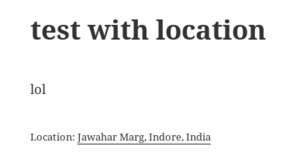


David Shanske tracks flight location on equipped planes on Android phones using Tasker scripts written for each provider.